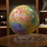
Sky & Telescope's Topographic Moon Globe
After the huge success of our Moon Globe, Sky & Telescope partnered with NASA to create a 12-inch topographic Moon globe, color-coded to highlight dramatic variations in lunar elevations. Impact basins and deep craters show up clearly in blue (the South Pole-Aitken Basin is particularly striking), whereas high peaks and rugged terrain are colored white, red, and orange. The new globe has about 850 labeled features.
We worked with the Lunar Reconnaissance Orbiter's Lunar Orbiter Laser Altimeter (LOLA) team to create the base maps, which show details as small as 0.5 kilometer across. LOLA determines terrain altitudes by firing pulses of near-infrared light and then measuring the roundtrip travel time of the reflections; the accumulated data yield topographic maps.
Developing the base map for the Topographic Moon Globe and ensuring its accuracy has been a team effort. But special commendations go to Illustration Director Gregg Dinderman, Senior Editor Kelly Beatty, Equipment Editor Sean Walker, and former Production Manager Mike Rueckwald. We also thank our friends on the LRO mission, at the U.S. Geological Survey, and at Replogle.
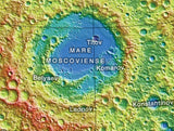
This globe’s vivid display of topography makes it easy to pick out dozens of the huge impact basins that scar the Moon’s surface. On the lunar farside, for example, you can easily pick out the gigantic depressions like Hertzsprung, Korolev, Orientale, and Mare Moscoviense. And the farside’s vast South Pole–Aitken Basin, 2,500 km (1,600 miles) in diameter, randks among the very largest impact sites anywhere in the solar system.
Did You Know?
The Moon always keeps one hemisphere facing Earth, and we had no idea what the Moon’s unseen half looked like until October 7, 1959. That’s when the Soviet Union’s Luna 3 spacecraft took the first pictures of the lunar farside, which turns out to have far fewer lava-covered “seas” than the nearside does.
ISBN 13: 9781940038667


